
SkylanIT has years of experience providing GIS software consultancy throughout the whole software development life cycle. To provide value-added insights, such as a cost-benefit analysis of using different technologies, our experts carefully analyze the business model of the client, ensuring the best possible use of their infrastructure.
Solutions for Data Management
At Skylan we use several solutions to optimize the use and performance of GIS software, so that it meets the specific needs of different projects of clients.
Application Software
Enabling Tools & Automation
- Task Automation: Develop automated workflows to simplify data analysis and map creation.
- Tool Customization: Tailor GIS tools to suit specific operational needs, such as data conversion or terrain modeling.

Maintenance and Support of Applications
- Regular Updates: It ensures the software is kept up-to-date with all the latest features and security patches.
- Issue Resolution: We provide ongoing technical support to resolve software-related issues promptly.
Software Testing
- Quality Assurance: We test the software for functionality, performance, and compatibility before deploying it.
- Bug Fixing: Under it we identify & fix bugs to improve software stability and reliability.

Technology Migration
Skylan technology migration services support the easy movement of our client’s applications and guarantee an easy integration with their current systems. It includes these things:
- Platform Upgrades: It involves migrating GIS applications to newer platforms to improve performance and compatibility with modern systems.
- Data Transfer: It will ensure easy transfer of data and functionality during technology migration.
- System Modernization: It upgrades outdated software to new technologies, reducing operational risks.

System Integration
Skylan system integration services help businesses to accomplish their goals by integrating GIS with their enterprise applications. It includes:
- Cross-Platform Integration: in it we integrate GIS software with other systems like ERP or CRM to improve workflow efficiency.
- Data Sharing: It enables seamless sharing and analysis of data across different platforms and departments.
- Interconnection: Ensure that different software components work together smoothly within the GIS ecosystem.
Enabling Tools & Automation
For it Skylan uses these following methods:
Project Management
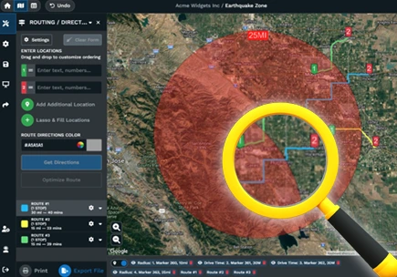
We use GIS software to track project progress in real-time. And monitor project resources, such as materials and labor, with geographical data.
Workforce Management
We use GIS tools to manage and allocate workforce resources based on geographic needs and automate scheduling of tasks such as data collection and fieldwork using GIS-enabled management systems.
Document Management
It enables users to query large GIS datasets effictively, and accessing relevant information quickly. It automates report generation based on query results for better decision-making.
Query Management System
It enables users to query large GIS datasets effictively, and accessing relevant information quickly. It automates report generation based on query results for better decision-making.


